Preserving the Park
In the last few years, according to the Devon Lions and the Lions
Campground Management, it is estimated that 6 to 8 feet of shoreline has been
lost, in particular, in the area adjacent to the Campground office. This, however, has never been actively marked
nor measured for the purposes of quantification.
Empirically, we are left with areal analysis
to approximate rates of erosion. Locals also point out the dogleg area of the roadway, being in
greatest proximity to the river bank, as having significant potential for
negative operational impact to the Devon Lions Campground. This is the area widely considered to be of
critical importance.

This area presents a significant concern due to the potential for
interruption of traffic flows and normal operations of the campground. An approximation of distance from
top of bank to nearest roadway construction at the time of this photo was
approximately 6.1 meters (approximately 19.7 feet), it has likely degenerated
to a modest degree since the time of this areal image. A foot inspection with GPS coordinate capture
will establish baseline data starting in 2013.
Given the low average of erosion over the last two years (in
accordance with local knowledge), the timeline for the expected impact of
operations, all else equal, would be some years away. Using the 4-year longitudinal average at a
rate of .7025 feet per year, the declination would be calculated as: (19.7 / .7025
= 28). Enhanced flow level years, when overtopping occurred, are not believed to be included in the four-year comparison. In general, it's safe to say the dogleg road area
isn't likely to wash out this year or even next year, even when adjusting for
shoulder easement and safe foot travel area.
Erosion accelerates by a combination of volume and rate of the flow
in the river. In other words, the amount
of water and how fast it flows has a powerful impact on the erosion rate. Overtopping the bank, i.e. "the big
flood", is a rare event and unlikely to cause substantial damage due to
the overtopping itself. Instead, it is the
power of the river and the rate of river flow sustained during overtopping
events that would have the most powerful impact on erosion. This, of course, is why precipitation levels
and dam release are central to a root cause analysis.
Extraordinary flooding circumstances create some amount of
erosion. Project engineers from both
commissioned firms, Peregrine and EBA, agreed when asked directly, that it is
the quantity of water and the flow rate of the water, as controlled by dam release,
that has, by far, the most considerable impact.
Geotechnical analysis should be focused on the area near the cabin,
the dogleg, and the area with the minimum extent of bank coverage. These were the sentiments agreed upon by the
Lions in conjunction with the meeting of the Town of Devon representatives. Upriver conditions were examined; visual inspections
did not report visible tension cracks. EBA states there is no risk of imminent riverbank
failure. The main roadway in the
campground could be compromised to traffic well before the riverbank erodes to
the point of contact.
Most erosion occurs during the major water release periods from
upriver dams. This may happen in
conjunction with heavy precipitation events or during times of high snowmelt
and glacial melt. Environment Canada records
show the majority of precipitation is recorded from May through September. Spring melt combined with substantial
precipitation events probably carries the highest potential for overtopping. The Peregrine consultant corroborated this
information during her immediate post-inspection visit and site de-brief.

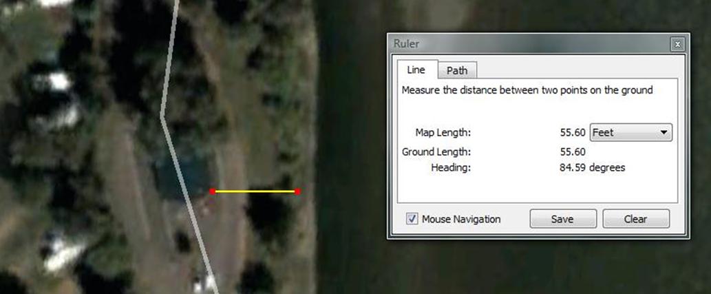
Google Earth shots available to the public were used for riverbank
erosion "rough" analysis. Two
data points by Google Earth applicable to this area were drawn from 2004 and
2008 data. A line was drawn from the
bottom (SE corner of the Cabin directly to the riverbank at approx. 85.xx
degrees < 1-degree variance and compared between the years 2004 and
2008. The year 2004 shows approximately
59.23 feet and the 2008 image shows approximately 55.6 feet. The rate of declination over the four-year
period approximated at 3.63 feet.

A second analysis was done using a fixed infrastructure point. In this case, the measurement was centered on
a fixed point and extended to the top of the bank as imaged overhead. The reduction of terrain appears to be
approximately 2.81 feet in this case. The
rate of bank erosion varies from area to area.
Compensation was applied for a < 1-degree variance, generally
compensated by selecting an anchor point in line with extended vegetation and a
clear demarcation of bank shading, indicating the exposed face of the riverbank.
Again, heading variance accounts for a minor distance variance,
probably less than a couple of inches.
This measurement is subjective on the riverside anchor point due to
vegetation changes and interruption of overhead resolution of the image, yet it is
probably a fair indicator. Close
examination also reveals lost vegetation, although the major trees appear to
remain intact. This could be the result
of pruning or the result of smaller vegetative features eroding into the
river. It is impossible to detect this
with low-resolution satellite imagery and the measurement should only be
considered a very rough estimate.


It seems unlikely that erosion rates would be consistent along the
course of the area under study, and the predominant hydrological factor affecting the rate would probably be the evident sand bar that exists in the river proximal to
the area of the cabin. Intuitively, it
appears to have the effect of slowing the rate in that area. As the river flow rate slows, sediment tends to
fall out or "sink" which would create and sustain a feature like this
sandbar.
As the river passes that zone and proceeds down the river, it seems to pick
up speed, thus predictive of a more rapid rate of recession in the downriver area. This presumptive estimate seems to have been
borne out by measurements. The EBA study
focused on the same area provides no analysis as to the rate of declination of
the land area. Their overhead imagery is the same source (Google Earth) with imagery taken from the 2008 posting of Google
Earth. The EBA study had no year-over-year comparisons or period-over-period analysis. Although the bottom right corner of the image
shows "2012", this refers to the access year of the image by the Google
Earth user.

The third area of analysis was set on the distal area of the driving
road anchored in the central traffic division feature that existed at both
points in time. The 2004 image shows
approximately 87.96 feet compared to the 2008 image at 81.71 feet, or approximately
5.25 feet of recession. Once again, the downriver
portion of the river study area appears to be showing a gain in velocity. In Saskatoon, a confluence near an erosion
riverbank area seemed quite similar to Washout Creek and suggested potential interplay
with erosion rates near the confluence with the North Saskatchewan, potentially
introducing another hydrological feature into the mix that could create
increased bank instability, which, as noted above, has been an ongoing issue in
the Saskatoon region.


The Bighorn dam created Lake Abraham, Alberta's largest man-made
lake. The Bighorn Plant generates enough
electricity to supply the equivalent of 58,300 Alberta households. The Bighorn embankment dam was built in 1972 in the mountain gap at Windy Point, in the Front Ranges of
the Canadian Rockies, west of the confluence of the
North Saskatchewan River and the Bighorn River, and is managed by TransAlta.
The Brazeau Dam is located in Brazeau County of Central Alberta, 55 kilometers (34 mi) southwest of Drayton Valley. It was developed along the Brazeau River,
at the confluence with Elk River, in the hydrographic basin of
the North Saskatchewan River. The Brazeau Dam is managed by TransAlta and produces 394,000 MWh per year, with a capacity of 355 megawatts.
Since release from the Bighorn and Brazeau are, in times of large
precipitation, largely interdependent,
the impact of water level and velocity are directly influenced by these
two dams. There are many factors that govern
water release. The upriver dams would
both have a considerable impact on flow rate and quantity.
The North Saskatchewan River is subject to the 1969 Prairie
Provinces Water Board Master Agreement on Apportionment (PPWB), which states that Alberta must
allow 50% of the natural flow of east-flowing rivers to enter
Saskatchewan. It also prescribes the minimum
flow required and water quality objectives (Alliance) . It is likely to release rates would be managed,
in part, by the PPWB master agreement.
The EBA project engineer who previously worked on the Shaw
Conference Centre armoring, and a City of Edmonton official, both indicated there
has been no effective way to generate release agreements designed to mitigate
erosion between hydroelectric operators and individual municipalities. It seems unlikely Devon would fare any
better. In addition to the requirements
of the PPWB Master Agreement, there are commercial considerations for power
generation.
Erosion appears blunted near the cabin due to the projection of the
pronounced sandbar. This is evidenced in
the 04-08 erosion rate of 3.63 feet. The
natural velocity of the river should tend to be slow immediately proximal to
the downriver side of the sandbar projection and then accelerate as it
progresses past the cabin area. This, in
turn, should present by way of further erosion rates on downriver trend as is
borne out by the 2004-2008 findings that show a similar rate of erosion at the
dogleg of 2.81. Cabin and dogleg
measurements are similar for rates of erosion.
The river apparently begins to pick up speed at the third measurement
point, advancing to a rate of 5.25 feet over the same period of time. These measurements can be precisely
calculated via surface GPS release floats, undercurrent speeds may also be
calculated in a similar manner. The
findings corroborate intrinsic knowledge and logical inference. Some flow rate and river level historical
records may be consulted to examine concerns of overtopping due to severe
floods. Some photographs of overtopping
events have been brought forward by local residents.
There are unknown hydrological implications of the washout creek
confluence and the interplay of aquifer recharge upstream of the confluence. Recharge influence over lateral instability
could logically result in an alluvial presentation of erosion proximal to the
confluence. Local knowledge suggests
there may exist one overflow pipe system for confluence drainage, probably
designed for overtopping mitigation of Washout Creek. Documenting and evaluating this drainage
system may turn out to be an activity with merit.
The City of Saskatoon has battled riverbank erosion since the early
part of the 20th century. Numerous
studies have been commissioned along with a variety of remediation efforts. Much of their efforts have surrounded subsurface
drainage systems in combination with berming of slopes and armoring of the riverbank. Their situation is largely influenced by the rate,
flow, and discharge of urban-influenced surficial aquifers and regional aquifers (A.W. Clifton, 1980) . Saskatoon has obtained favorable results with
berming and riverbank armoring.
To my knowledge, a stratographic assessment of the Lions Campground has
never been done, which precludes an understanding of aquifer recharge
implications relative to stratographic identification of potential erosion or
"slide" areas. There may be some merit in considering a
stratographic assessment of drift and underlying till. An image of the stratographic assessment of
the 18th Street cross-section from Saskatoon is included as a reference.

It is possible an inferred slip zone could be negotiated
scientifically, but it should also be noted that an intrinsic geologic
understanding of this area could rule out the need to undertake such an assessment. Stratographic interpretation has not been discussed
by EBA or Peregrine but has been a component of both the City of Saskatoon and
the University of Alberta College of Engineering studies cited herein. In other words, the one integrated science
both the commissioned reports did not have.
In the event of overtopping, such an assessment would seem to be more important
relative to the inland embankment upon which housing is situated.
Natural Resources Canada produced a comprehensive geoscape of the
Saskatoon area (Canada N. R.) . NRCAN research also described coarse rock
berms as a contra-erosion feature leveraged for bridge protection in low-lying
areas, which is in line with coarse rock berm armoring undertaken at the Shaw
Conference Center. Appropriate
geological advice prior to discarding the idea of a stratographic study out of
hand might be warranted, although it seems unnecessary to our goal of
protecting the campground from lateral erosion of low-lying areas and preventing
the loss of corresponding parkland features of the campground.

Geoscape contextualization demonstrates the integrated science
approach to erosion analysis (Canada E. ) . Conducting a spatial imaging pattern
recognition analysis of the river might be warranted. This could be attained through the Government
of Alberta archives for imagery and possibly accessing data from the Spatial
Information Systems Laboratory (SISL) at the University of Alberta. Academic dialogue with leading hydrological,
geotechnical, geological, and geophysical resources should not be discarded out
of hand when it is possible for the SISL could provide access to GIS data and mapping
software at little to no cost with possible collateral interactions with
multidisciplinary scientists.
One thing is certain; we are not alone. Edmonton's river valley has also been the subject of considerable study. In every study related to riverbank erosion that I have consulted, they have all included stratigraphic and topographic considerations of relative geology in the immediate area of concern.

Referenced is a study undertaken by the University of Alberta in
conjunction with the physical expansion of the University. The study was headed by the Dean of the
College of Engineering (S. Thompson, 1978) . The conclusion of that report spoke directly to
lateral erosion. The University of
Alberta, the Shaw Conference Centre, and the City of Saskatoon implemented
berming and riverbank armoring. In the
case of the University of Alberta, riprap facing was employed using a variety
of sizes. The sizes were carefully
selected depending on calculated erosion forces given estimated flow rates. The University of Alberta also concluded that
lateral meandering is more significant than valley downcutting.
The University of Alberta study noted the economic cost of riverbank
stabilization work to be substantial. The
annual cost of riverbank stabilization approaches the value of land protected,
thus they argued the only case that justifies such measures would be those
instances where it would impact public use and recreational activities… as is
the case in Devon.
The Town of Devon and the Devon Lions Club are two highly impacted
stakeholders. As such, the Devon Lions
Club has appointed by resolution of the General Membership, two
representatives to liaise between the Devon Lions Club and the Municipality. Areas of primary concern and action items outlined
by the EBA study focus on continued bank monitoring and structural
engineering analysis of the existing walls and bank protection mechanisms to
insure ongoing stability. Plans are
being developed to protect the campground from further bank erosion through the
measure of adding "armoring" to the riverbanks.
After considerable independent research, I agree that vulnerable zones should receive armoring, although the riprap should be properly determined as per the University of Alberta study. Given my knowledge of the beliefs of the local people, I think armoring the high-risk sites, namely, the cabin to the dogleg area would alleviate the highest concerns while protecting against the most expensive issue, the potential relocation of a roadway. It is probably wise to explore an initial armoring phase in this area. This would be a highly visible project providing physical reinforcement.
Riverbank armoring may not actually require approvals of other
levels of government so long as the equipment used to undertake the armoring is not
required to enter the river properly. This
should be investigated at the outset of any planning to prevent any possible
issues with other levels of government.
Both consultants suggested low precipitation months as being optimal
for work schedules. Materials may exist
by way of the Town of Devon sidewalk and curb replacement program rubble, or
some form of riprap, appropriately sized and suitably esthetic. Given the timelines, a planning phase could
extend from early 2013 to late Spring 2013 or Summer, so as to accommodate
public input and leverage a consultative process. This would allow time to undertake
ingress/egress arrangements to the riverbank at project commencement. When river flow reduces in the Fall or early
Winter of 2013/2014, work could be undertaken.
Major improvements could be budgeted across fiscal years, with long-range
ongoing investment through the 2014 - 2017 range if deemed feasible. Further, a member of the Lions Club noted
there was a pathway on the riverbank.
Given the River Valley Alliance (RVA) funding and the pre-existing path
structures that connect the RVA, there may be some partial offsets to bank
stabilization expenditures.
There have been some discussions relative to making other changes in
the River Valley. These include an
extension of the existing boat launch or possibly the addition of another boat
launch. Whatever these plans are, some
amount of consideration should be given to those plans so that any work was undertaken to prevent riverbank erosion would not create undue conflicts with
future projects.
Cited
A.W. Clifton, J. K. (1980). Riverbank
instability and development control in Saskatoon. Saskatoon: 1980.
Alliance, N.
S. (n.d.). About the Watershed. Retrieved November 21, 2012, from North
Saskatchewan Watershed Alliance:
http://www.nswa.ab.ca/content/about-the-watershed
Almanac, F.
(n.d.). 2013 Long-Range Weather Forecast for Edmonton, Alberta.
Retrieved November 21, 2012, from Farmers Almanac: http://www.almanac.com/weather/longrange/AB/Edmonton
Canada, E.
(n.d.). Environment Canada. Retrieved 11 18, 2012, from National
Hydrological Resources Centre: http://www.ec.gc.ca/scitech/default.asp?lang=En&n=44EEFEB3-1#nhrc
Canada, N.
R. (n.d.). The Trouble With Valley Slopes : Landslides. Retrieved 11 28,
2012, from Natural Resources Canada Earth Sciences:
http://www.nrcan.gc.ca/sites/www.nrcan.gc.ca.earth-sciences/files/pdf/sask/pdf/geoscape_southsask_landslides_e.pdf
EBA - A TERA
TECH COMPANY. (2012). Riverbank Erosion and Stability Assesment North
Saskatchewan River. Devon: A.F. (Tony) Ruban, M.Eng., P.Eng., Brian C.
Adeney, P.Eng.
S. Thompson,
D. T. (1978). River erosion and bank stabalization - North Saskatchewan
River, Alberta. Edmonton: Department of Civil Engineering, University of
Alberta.